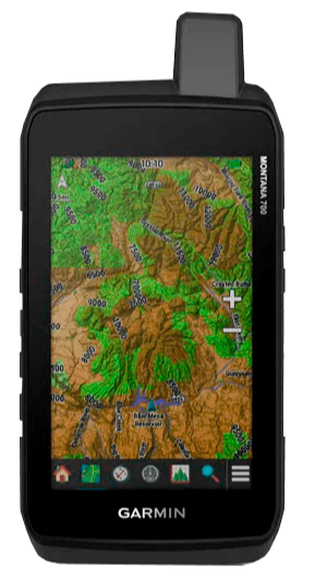


GPS NAV GARMIN MONTANA 700
Codigo: 1336
0
Calificar
Ofertas Servicios Cursos IniciarAccesorios incluidos (Imágenes referenciales)GPS 66s y cable de transferencia CARACTERÍSTICAS:DIMENSIONES DE LA UNIDAD: 3,4 ´x 7,2´ x 1,3 ´(8,76 x 18,30 x 3,27 cm)PANTALLA TACTIL: siTAMAÑO DE LA PANTALLA: 2,55 ´de ancho x 4,25´ de alto (6,48 x 10,80 cm); 5 ´en diagonal (12,70 cm)RESOLUCIÓN DE PANTALLA: 480 x 800 píxelesTIPO DE PANTALLA: WVGA transflectiva, orientación dualPESO: 14.0 oz (397 g) con paquete de batería de iones de litio incluidoTIPO DE BATERIA: iones de litio recargables (incluidas) o 3 pilas AA (no incluidas); litio recomendadoDURACION DE LA BATERIA: Modo GPS: hasta 18 horas Modo Expedición: hasta 330 horasRESISTENCIA AL AGUA: IPX7RECEPTOR DE ALTA SENSIBILIDAD: siINTERFAZ: Compatible con micro USB de alta velocidad y NMEA 0183MEMORIA / HISTORIA: 16 GB (el espacio del usuario varía según el mapeo incluido)MIL-STD-810: sí (térmico, choque, agua, vibración)MAPAS Y MEMORIA: MAPAS PREINSTALADOS: sí (TopoActive Sudamérica)POSIBILIDAD DE AGREGAR MAPAS: siMAPA BASE: siCREACIÓN AUTOMÁTICA DE RUTAS: Sí (con mapeo opcional para carreteras detalladas)MAP SEGMENTS: 15000BIRDSEYE: sí (directo al dispositivo)INCLUDES DETAILED HYDROGRAPHIC FEATURES: siINCLUDES SEARCHABLE POINTS OF INTERESTS: siDISPLAYS NATIONAL, STATE AND LOCAL PARKS, FORESTS, AND WILDERNESS AREAS: siALMACENAMIENTO: sí (tarjeta microSD ™ de 32 GB como máximo)WAYPOINTS: 10000TRACKS: 250RUTAS: 250, 250 puntos por ruta; 50 puntos de enrutamiento automáticoREGISTRO DE RINEX: siREGISTRO DE TRAYECTO: 20000 puntos, 250 pistas gpx guardadas, 300 actividades de ajuste guardadasSENSORES: GPS: siGLONASS: siGALILEO: siALTÍMETRO BAROMÉTRICO: siBRÚJULA: Sí (3 ejes con compensación de inclinación
GPS 66s y cable de transferencia
Marca: SIN MARCA
COMPRA SEGURA. Al comprar por Geonet su dinero esta protegido.
Un producto verificado es un producto de segunda mano que ha pasado por nuestra verificación en un laboratorio Geonet. ver hoja de verificación
GPS 66s y cable de transferencia
Marca: SIN MARCA
COMPRA SEGURA. Al comprar por Geonet su dinero esta protegido.
Un producto verificado es un producto de segunda mano que ha pasado por nuestra verificación en un laboratorio Geonet. ver hoja de verificación


Regístrate ó inicia sección para Ver precios